While doing some research on biodiversity patterns and ecoregions today, I came across two very interesting articles:
This first one is older than I am:
The ecologist as Zen master
The Conservation Biologist as Zen Student
I've been doing a lot of reading on atheism lately (namely Sam Harris' last two books) and it's nice to see science(ecology) and religion(zen, some forms of which I tolerate) be brought together in a coherent way in these two articles.
National Geographic Work
I will have a 3 page spread map of the Brazilian Amazon in the January issue of National Geographic Magazine. I worked closely with Bill McNulty (the magazine's Director of Maps) to put it together and we are both happy with the way it turned out. Nasa Blue Marble imagery and SRTM 30 data was used in combination with MODIS Land Cover data from Boston University and fire data from the MODIS Rapid Fire team. It's an honor to have work published in the magazine.
Move to PG
It's now official, at the end of December I will be moving to Prince George, Central British Columbia to work on Glacier Mapping full time and finish my masters degree there. Here is what I'll be working on:
Western Canadian Cryospheric Network
Here is a brief sumary of my research objectives:
Fuzzy Object Classification Towards Change Detection of Glacier Extent
We propose to use polygons of glacier extent derived from topographic maps as a starting point in a change detection analysis using Landsat and ASTER imagery to determine glacier extents. Fuzzy object metrics describing thresholds, gradients and transitions of texture, spectral characteristics, topology, and terrain morphology are considered in the change detection process. Additionally, current land cover will be mapped with a particular emphasis on identifying periglacial lakes, ablation, accumulation and debris covered areas. This approach is being tested at seven glacier sites in British Columbia and Alberta to determine an appropriate methodology for use in a larger, inter-provincial glacier inventory. Modern classification methods including neural networks, decision trees and classical methods such as maximum likelihood and isodata classifiers will also be tested with and without image segmentation, and with pre- and post-classification segmentation. These methods will be evaluated against expert derived glacier boundaries thus permitting a robust assessment.
Keywords: Change Detection, Glacier, Classification, Object-Oriented, Canada-Western
I also plan on focusing more effort on terrain depiction research using LIDAR and other remote sensing tools including object-oriented classifiers and texture filters. i'll also be continuin my work on continuous data and dasymetric mapping for landcover depiction at landscape scale.
Thursday, November 09, 2006
Thursday, August 24, 2006
Granite Peak Map Published
First Ascent Press of Montana has published my 1:24,000 topo map of Granite Peak, Montana's highest point at 12,799'. I'd been working on the map with FAP's Joe Josephson for the last year so it's nice to see it in print as it's my first map printed on a synthetic stock and my first topo map for a Unisted States area. I now understand why it is necessary to score the sheet prior to folding.
Get it here: http://www.firstascentpress.com/granitepk.html
Get it here: http://www.firstascentpress.com/granitepk.html
Sunday, March 19, 2006
Diffuse Illumination

When can we expect this to be implemented into any commercial software?
The image above is from Patrick J. Kennelly and A. James Stewart. A Uniform Sky Illumination Model to enhance Shading of Terrain and Urban Areas. Cartography and Geographic Information Science (2006) 33: 21-36.
.....................................................
Music this week: The song 7/1000 by Voltadomar, The song Daniel by Bonnie 'Prince' Billie and Tortoise and the Sleeping People album...The last two acquired at reckless records in Chicago...a great record store.
Saturday, March 18, 2006
33rd ACSM CaGIS Map Design Award
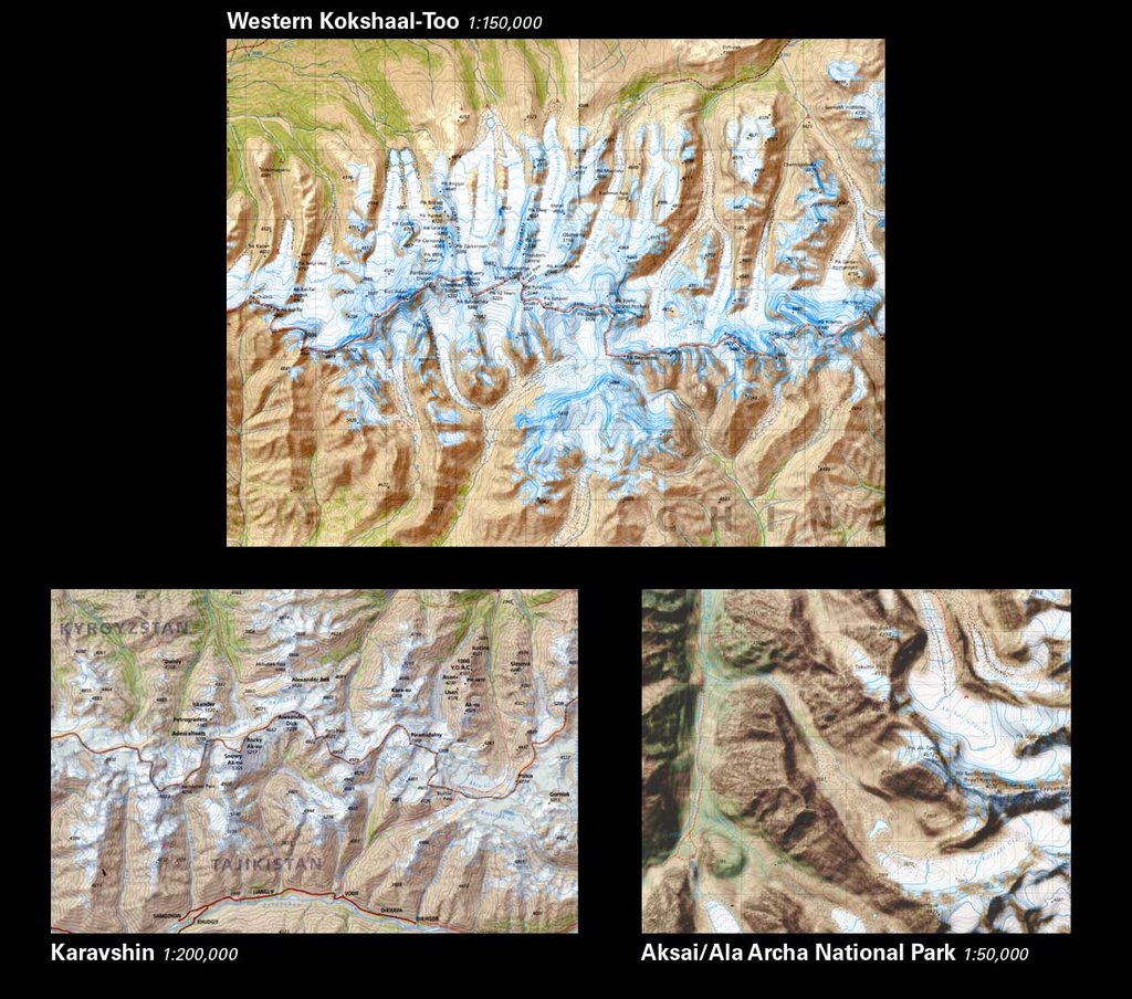
The AAC Kyrgyzstan work was awarded an Honourable Mention. This is good news for us:
Official CaGIS page
I am leaving for Slovenia in less than one week to attend the ICA Mountain Cartography Workshop in Bohinj in the Julian Alps. This should be exciting and I am looking forward to seeing friends and colleagues. I'll be giving a presentation on what the AMG has been up to, including discussion of the Kyrgyzstan work. In particular I'll be talking about the generalization of land cover information obtained from classifying satellite imagery. This is something I am particularly interested in these days.
Thursday, February 09, 2006
PCI Orthoengine 10 a bit unstable.....
Music: Burning Airlines identikit 2001
Good news: Three Mile Pilot is recording a new album!
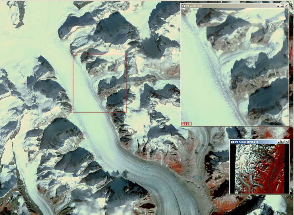
Bad News: PCI Orthoengine V.10 is a behaving badly
For example today I spent some time trying to orthorectify the ASTER VNIR image shown above. It is 15m resolution and has alot of elevation changes and steep mountain faces, lots of low contrast brigh glacier pixels, some clouds and deep shadows...all in all a nightmare image. I have an O.K. DEM created from some USGS vectors. Not an ideal surface to work with because of the resolution but better than nothing. Yesterday we discussed image to image registration in my image processing class. My previous attempts at correcting this image where all with the vectors from the topo map....so I began to think about trying to use a corrected Landsat ETM+ Pan band to collect GCPs. My first attempt was going well, I had 16 GCPs...did I mention I installed the new version of Orthoengine yesterday....and unfortunately assumed it had been tested and would be relatively bug free.....ooooops....so yes, 16 GCPs and my RMSE was pretty high due to 2 points that I decided to remove. Sadly this resulted in a crash and all subsequent attempts give the same result...crashes when deleting GCPs!!!
Anyone that has done this knows how tedious collecting GCPs is, and when you've got it good you dont want to start over!
Had an interesting lecture on Classification/Pattern recognition today. Looking forward to getting into neural networks on Friday...
Things on my mind:
Dasymetric Mapping
VCF approach to landcover/vegetation mapping for Auzangate region.
My presentation on: The Evolution of Landsat Data Analysis
Ordered a copy of this Atlas produced by Geographx an New Zealand mapping company. If they were hiring I'd be ready to move down under. I can honestly say that it has been a while since I saw work that impressed me so much. I can't wait to see the real thing.
-------------------
Geneology...saw the Skip Gates series on PBS last night. It really made me wonder about my roots. Oprah and other folks were talking about how they wanted to have Indian heritage when they were kids. It never occured to me growing up...but a couple years ago my mom told me she and her sisters suspected that her great paternal grandmother was a native from the maritimes (Micmac or Malecite maybe?)....So I'm thinking of doing some reasearch on this and putting a geneological map together that will link all these ancestries together....
Tuesday, January 24, 2006
Canada election Maps
Where are the maps?
Everything I've seen is interactive.. Is interactive synonymous with crap?
How long do we have to wait to see the spatial distribution of the results, to look for patterns, to see how our neighboring ridings or old haunts voted?
Canadian media what are you up to...hire some
CARTOGRAPHERS
Everything I've seen is interactive.. Is interactive synonymous with crap?
How long do we have to wait to see the spatial distribution of the results, to look for patterns, to see how our neighboring ridings or old haunts voted?
Canadian media what are you up to...hire some
CARTOGRAPHERS
Subscribe to:
Posts (Atom)